Department of State

Office of Planning Advocacy

The Hon. Tahesha Way, Lt. Governor and Secretary of State

Mapping

Land use decision support requires good data and information. OPA's Research Unit supplies the office and agencies, non-profits and businesses statewide with mapping, demographics and analysis to fulfill this mission.

NJ Department of State Office of Planning Advocacy Locator Map

Maps and GIS Data

The New Jersey Office of Smart Growth uses state-of-the-art computer graphics and geographic information systems to prepare a variety of map products.

While certain map products are prepared at a statewide or county scale, maps are commonly produced at a 1:24,000 scale corresponding to U.S. Geological Survey topographic quadrangle maps. At this scale, the standard accuracy of mapping is usually within (plus or minus) 45 feet.

Map Update Email Notification
To receive notice via email about updates to the State Plan Policy Map, please email the Office.

State Plan Policy Map

The official map of the New Jersey State Development and Redevelopment Plan is called the State Plan Policy Map. The scale of the official map is 1:24,000. A series of maps produced at this scale, which match the 7.5 minute scale geographic quadrangle maps produced by the United States Geological Survey, are available in hard copy format from the Office of Smart Growth as well as in various digital formats.

Maps updated: 07/07/21

Quad Maps

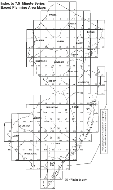
Quadrangle scale (1:24,000) maps (reproductions of official State Plan Policy Maps), 24x30” are available in hard copy format. A full set consists of 176 maps.

To find the quad(s) for your municipality, consult the Municipalities Quad List

Quad scale maps are also available in PDF format. Select each quad by clicking on the appropriate area of the map or in the table below.

All Quads are official as adopted by the State Planning Commission on March 1, 2001 and up to date as of 07/07/21.

Index to State Plan Policy Map quads Quad 058 Quad 002 Quad 027 Quad 039 Quad 013 Quad 014 Quad 048 Quad 038 Quad 028 Quad 040 Quad 052 Quad 043 Quad 020 Quad 041 Quad 029 Quad 050 Quad 049 Quad 037 Quad 006 Quad 005 Quad 056 Quad 019 Quad 010 Quad 009 Quad 003 Quad 059 Quad 025 Quad 046 Quad 053 Quad 011 Quad 018 Quad 057 Quad 008 Quad 015 Quad 036 Quad 004 Quad 007 Quad 016 Quad 063 Quad 031 Quad 051 Quad 044 Quad 045 Quad 047 Quad 024 Quad 034 Quad 033 Quad 032 Quad 042 Quad 030 Quad 022 Quad 023 Quad 021 Quad 035 Quad 060 Quad 061 Quad 001 Quad 055 Quad 012 Quad 017 Quad 062 Quad 026 Quad 973 Quad 074 Quad 073 Quad 072 Quad 071 Quad 070 Quad 069 Quad 068 Quad 067 Quad 066 Quad 092 Quad 091 Quad 083 Quad 983 Quad 082 Quad 081 Quad 078 Quad 077 Quad 076 Quad 089 Quad 088 Quad 154 Quad 090 Quad 098 Quad 087 Quad 080 Quad 079 Quad 096 Quad 101 Quad 100 Quad 099 Quad 992 Quad 111 Quad 086 Quad 095 Quad 108 Quad 097 Quad 106 Quad 105 Quad 104 Quad 153 Quad 152 Quad 109 Quad 107 Quad 110 Quad 141 Quad 123 Quad 118 Quad 121 Quad 120 Quad 145 Quad 131 Quad 149 Quad 128 Quad 135 Quad 134 Quad 117 Quad 115 Quad 148 Quad 133 Quad 114 Quad 140 Quad 112 Quad 127 Quad 103 Quad 147 Quad 119 Quad 132 Quad 138 Quad 146 Quad 139 Quad 129 Quad 130 Quad 143 Quad 142 Quad 122 Quad 158 Quad 159 Quad 126 Quad 116 Quad 113 Quad 144 Quad 136 Quad 157 Quad 156 Quad 151 Quad 150 Quad 137 Quad 155 Quad 094 Quad 093 Quad 102 Quad 165 Quad 125 Quad 124 Quad 162 Quad 169 Quad 164 Quad 172 Quad 171 Quad 167 Quad 166 Quad 175 Quad 174 Quad 163 Quad 160 Quad 168 Quad 9173 Quad 173 Quad 178 Quad 177 Quad 170 Quad 176 Quad 161


GIS Data

Spatial data for use in geographic information systems and desktop mapping software are available online. Select layers constituting the State Plan Policy Map and other maps are available as shapefiles. Metadata is provided where available.

Files are available in compressed (ZIP) files.Use of this data is subject to the conditions of our End User Licensing Agreement.

These data files are designed to be used in combination with coverages from other agencies and vendors for geographic analysis. They are in New Jersey State Plane (1983) coordinates and coverages may need to be re-projected by the user for compatibility.

Unless otherwise noted, files are current as of 07/07/21
State Plan Layer Package 07/07/21 State Plan Layer Package
Planning Area Boundaries 07/07/21 PAB Geodatabase PAB Metadata
Designated Centers (Planned Centers Removed) 07/07/21 DC Geodatabase DC Metadata
Nodes 04/06/21 Nodes Geodatabase Nodes Metadata
Cores 01/16/18 Cores Geodatabase Cores Metadata
Urban Complex 08/19/15 UC Geodatabase UC Metadata
Endorsed Plans 07/07/21 ED Geodatabase ED Metadata
Critical Environmental & Historic Sites (CEHS) 04/06/21 CEHS Geodatabase CEHS Metadata
Historic and Cultural Sites (HCS) 10/11/01 HCS Geodatabase HCS Metadata
Smart Growth Areas 07/07/21 SGA Geodatabase SGA Metadata
Brownfields SiteMart 03/26/15 BFS Geodatabase BFS Metadata
NJ Colleges and Universities by Parcel 08/17/17 NJC Geodatabase NJC Metadata
NJ Foreign Trade Zones 04/27/15 NJF Geodatabase NJF Metadata
NJ Sports and Exposition Authority Land 10/13/16 NJS Geodatabase NJS Metadata
Fort Monmouth Reuse and Redevelopment Areas 06/28/13 FMR Geodatabase FMR Metadata
Ferry Terminal Embarkation Points 05/06/14 FT Geodatabase FT Metadata
HUD Choice Neighborhoods 09/24/13 HUD Geodatabase HUD Metadata
Atlantic City Tourism District 10/10/13 ACT Geodatabase ACT Metadata
All Center Boundaries (Includes Planned Centers) 07/07/21 ACB Geodatabase ACB Metadata
Identified Centers (No longer in use) 07/07/21 IC Geodatabase IC Metadata


New Jersey Business Action Center End User License Agreement


Page Last Updated: 07/12/21


Back
to top